Accuracy makes all the difference.

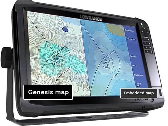
According to one published report, the maps available in the “vast majority of electronic cartography” are based on historical data from governmental agencies – data often 50 years old or more!
To get “1-foot contours” for maps of such lakes, companies run a computer program to estimate depths between government-drawn contours lines and then just fill in the blanks. That’s why you often see structure on your sonar screen where your map shows nothing.
C-MAP Genesis allows you to record your own sonar data, upload that to our cloud-based database and start seeing detail that isn’t available anywhere else.
Active Bodies of Water

Earth Hours on the Water

Countries Contributing

Know where to go.
Know what to throw.
-

Contours You Can Trust
Ever found a hump, ditch or drop-off not on any map? C-MAP Genesis creates contours you can trust, revealing fish-holding structure other maps miss.
View Feature -

Vegetation Map
Big fish ambush little fish in submerged vegetation. Genesis Edge maps show the location, shape and depth of grass flats, deep weedlines, isolated patches and more.
View Genesis Edge -

Bottom Hardness Map
Fish love hard bottoms. They feed on 'em, breed on 'em, follow their edges like roads. Genesis Edge maps show the location, shape and depth of hard-bottom areas.
View Genesis Edge
The Genesis Live file (.GSD) can now be uploaded to your account.
View PostDownloading Multiple Social Map Tiles
View PostWhat have you done to the Social Map?
View PostBottom-hardness layer available now for thousands of C-MAP Social Map charts, with Genesis Edge subscription
View PostC-MAP Reveal charts feature photo-realistic sea floor imagery for Simrad, Lowrance, B&G users
View PostCompatible Devices
Start catching the biggest fish of your life.
Genesis Social
Upload personally mapped areas to the Social Map queue
Unlimited download of Social Map charts
Custom-color depth shading of downloaded charts for certain chartplotters
Create and get updates on Favorite Waterbodies
See list of recently uploaded sonar logs in your dashboard
Access to Bottom Hardness Social Map Charts
Automated creation of custom depth, vegetation, and bottom hardness maps
Personal trip and map lists archived online
Trip Viewer on all uploaded trips
Merge multiple trips into a single output and chart
Option to keep private any areas personally mapped
Genesis Edge
$99
/yearUpload personally mapped areas to the Social Map queue
Unlimited downloads of Social Map charts
Custom-color depth shading of downloaded charts for certain chartplotters
Create and get updates on Favorite Waterbodies
See list of recently uploaded sonar logs in your dashboard
Access to Bottom Hardness Social Map Charts
Automated creation of custom depth, vegetation, and bottom hardness maps
Personal trip and map lists archived online
Trip Viewer on all uploaded trips
Merge multiple trips into a single output and chart
Option to keep private any areas personally mapped
Custom-Color Depth Shading
Select from 16 colors to highlight as many as 10 customized depth ranges on both Social Map charts and private Genesis Edge maps. You can set two separate custom-color depth palettes for every map and easily highlight the fish-holding areas. Humps and holes, reefs and shoals, drains and ditches, ledges and breaklines will all be much more visible when set apart with custom-color depth shading.
Pro Tip: Synch a Lowrance HDS unit with Motorguide’s xi5 Pinpoint Lowrance Gateway, and you can easily set your trolling motor to autopilot your boat to follow your custom-color-shaded depth contours.
Custom depth shading is compatible with Lowrance HDS Gen 2, HDS Gen 3, Carbon and Elite Ti units. It is not compatible with Lowrance Hook and Lowrance Elite HDI, Elite CHIRP and Elite DSI units.Bottom Hardness on Social Map and Private Maps (Edge)
Many fisherman “beat the bank” because they have more confidence targeting visible shoreline cover than offshore bottom structure. Those shallow fish get pounded hard, making them harder to catch. With a Genesis Edge bottom-hardness map you can fish the bottom as confidently as you do the bank, targeting the most productive places: offshore structures like ledges, sunken islands, saddles and more.
It overlays onto your contour lines a color-coded representation of the size, shape and location of areas of different bottom hardness: dark orange areas show the hardest bottom; a lighter orange indicates the next-hardest bottom; tan is the next-hardest bottom; and pale yellow shows the softest-bottom areas.
Submerged Vegetation Map (Edge)
It’s no secret that big fish ambush baitfish in submerged vegetation. What’s not always known is where the good green stuff is and what areas within it likely hold the most fish. In most weather and water conditions, submerged vegetation is not visible to the naked eye, so you have to go searching for it. And even when you see a patch on your sonar screen, you won’t know its full size, shape or thickness.
Genesis Edge’s vegetation layer shows fish-holding holes in vast grass flats, depicts fish-populated points and inside-turns on deep weedlines and more. It places bright-green overlays the size and shape of areas of submerged vegetation atop your blue contour map, making it as easy to see the best places to cast as when you’re throwing to visible cover like docks and laydowns.
Trip Viewer (Edge)
C-MAP Genesis not only creates maps with 1-foot contours and a bottom-hardness layer for your favorite waterbodies, it literally records your dynamic 200hz sonar screen, creating, essentially, a trip viewer of every fish, bait ball, rock, hump or hard spot you drove over. This gives you a second chance to waypoint fish or structure after the fact, back at home, if you missed them while on the water. You can then export those "2nd chance waypoints" back to your compatible Lowrance, Simrad or B&G sonar/GPS unit and then pilot your boat directly to the areas they mark and get on a bite.
Custom Contour Maps
If there’s currently no map of your favorite waterbodies, the benefits are immediately apparent. If there IS an existing map of your favorite waterbody, how accurate is it? To get “1-foot contours” for maps of such lakes, companies can run a computer program to estimate depths between government-drawn contours lines and just fill in the blanks.
With C-MAP Genesis you can create 1-foot contours you can trust .You can discover and dissect “spot-on-the-spot” areas unknown to other anglers.
Blue-shaded depth gradations on your Genesis maps will make the structure you discover more apparent at a glance: darker blue indicates deeper water and lighter blue indicates shallower water.


